|

"Jemez Mountains" Poster
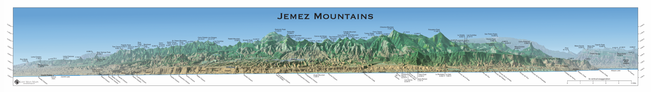
Profile view of Jemez Mountains, New Mexico. Elevation view from the east with all peaks and landforms labelled. Measures 50"x7". Prints are not available, but this poster can be freely downloaded in PDF format here (72 Mb file). It will be printable on any plotter. I obtained great results printing at Aspen Copies and then getting it cut to size and mounted on foam core at Village Arts, both in Los Alamos. Village Arts has a full-size, mounted print on display. "The Cascades of Northern Oregon" Poster
"The Cascades of Northern Oregon" is no longer being sold online or at retail stores. Prints are not available, but this poster can be freely downloaded in PDF format here (77 Mb file). Description: 24" x 52" poster depicting the Cascade Mountains through the northern half of Oregon with all named peaks and major landforms labeled. The range is shown in stunning detail at 5x vertical exaggeration, and additionally at actual proportions for visual reference. The poster also includes five close-up views of the major mountains of the range. Features:
Samples:
The Pacific Northwest Panorama
|


Lost Man Maps is a custom cartography studio specializing in maps and 3-dimensional visualizations of mountains and other natural features.

All images and information Copyright © 2003-2019 by Lost Man Maps/Matthew Hoffman & Amanda Barry.
All images licensed CC BY-NC 4.0.

This work is licensed under a Creative Commons Attribution-NonCommercial 4.0 International License.